Improving estuary water quality monitoring in Nelson
Nelson City Council is taking a closer look at how much sediment is flowing from rivers into the region’s estuaries as part of a programme to improve estuarine water quality monitoring.
Measuring river sediment loads to estuaries is one of a number of recommendations being considered by the Council, following their commission of an Envirolink(external link)-funded report. Prepared by NIWA in April 2019, the report provides advice on the design of an estuarine water quality monitoring programme for four Nelson estuaries: Waimea Inlet, Nelson Haven, Delaware Estuary and Kokorua Inlet.

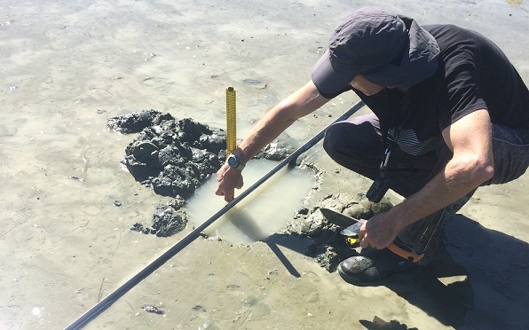
Measuring sediment deposition at a buried sediment plate, Delaware estuary, Nelson.
The advice on measuring sediment loads to estuaries has been instrumental in developing the Council’s sediment monitoring strategy and moving forward with an implementation plan, says Nelson City Council’s water quality scientist Dr Paul Fisher.
“The advice has supported a robust approach when it comes to planning and costing a coastal water quality monitoring programme,” he says.
“Estuaries are literally where the land meets the sea, so they’re exposed to a range of environmental stressors and natural change, including coastal development and climate change.
“They’re dynamic environments and host our most diverse habitats, which makes them interesting but challenging to monitor.”
As a result of the Envirolink report, Nelson City Council will increase the frequency of monitoring sediment flowing into the estuaries, by measuring continuous turbidity and the concentration of suspended sediment. Over the next three years, they will install continuous turbidity sensors and will auto-sample suspended sediment in three of the catchments.
“The focus on sediment monitoring is timely because of the proposed inclusion of a national sediment monitoring attribute for freshwater management, plus the environmental pressures that are impacting the wider region and Tasman Bay.”
The Council has invested significantly in infrastructure to make the high-frequency sediment monitoring possible and is providing ongoing support to maintain monitoring equipment and validate results.
“Long term, the high-frequency monitoring will underpin and add value to other monitoring programmes, including forecasting recreation bathing water quality, and validating modelled sediment and nutrient loads to our estuaries,” Paul says.
Establishing an estuarine water quality programme is part of a larger strategic plan to integrate mountain-to-sea monitoring and to develop a coastal monitoring programme that is responsive to local stressors and resource uses.
The Envirolink report included a number of other recommendations that complement existing monitoring programmes, including the number and location of monitoring sites, sampling methods, and water quality variables.
The Envirolink scheme(external link) funds research organisations to provide regional councils with advice and support for environmental research.
Last modified: