LiDAR assessment of sediment loads
Application of LiDAR differencing to assess sediment load for the Upper Waipaoa River
The Waipaoa River catchment drains from the Raukumara Ranges out to sea just south of Gisborne city. The river is recognised both nationally and internationally for its high rates of landscape erosion, high sediment load and rapid aggradation of the riverbed level.
Since 1960, reforestation in the Upper Waipaoa catchment has been successful in reducing sediment loads from the catchment, particularly in the headwater areas. Despite this, riverbed levels have continued to rise resulting in channel narrowing and a reduction in the Waipaoa River Flood Control Scheme (WRFCS) capacity.
Gisborne District Council (GDC) acquired airborne LiDAR data for the entire Gisborne region between 2019 and 2020. LiDAR was also sourced for parts of the Waipaoa River catchment in 2005.
GDC is exploring ways to maximise the value of its investment in capturing airborne LiDAR and wanted to assess the potential to use large-scale LiDAR differencing to assess the environmental risks (particularly the enhanced risk of flooding) associated with the changing sediment supply to the WRFCS. Utilisation of LiDAR differencing at a catchment scale may hold potential for detecting sites of high sediment yield which could allow improved targeting of focused management interventions.
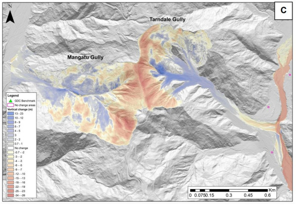
LiDAR differencing results - Tarndale and Mangatu gullies.
GDC wished to compare the 2005 and 2019 datasets to quantify changes in riverbed elevation and channel morphology for the upper Waipaoa River channel as well as to estimate the rates of net sediment transfer through the study reaches. GDC were successful in obtaining an Envirolink Grant (2137 GSDC165) for this study and contracted GNS Science to provide this expertise.
The main objectives of the work were:
- Understanding the sediment fluxes within the river system and identifying potential risk from changing sediment rates to the WFCS;
- Supporting flood hazard modelling for the Poverty Bay Flats;
- Improving understanding of sediment accretion and depletion on beaches between the Waipaoa river and Gisborne city to inform ongoing decision making and understanding long-term risk under climate change;
- Providing tools to allow for the application of LiDAR differencing in vulnerable catchments;
- Providing a measure of the success of the erosion control funding programme in the mitigation of erosion and sediment losses in the Waipaoa Catchment.
GDC Principal Scientist Murry Cave explained that the critical part of the work was assessing the potential impacts of deposited sediment on key flood management assets. Murry says “with Cyclone Gabrielle affecting the region in February 2023 we now need to repeat the analysis to see the weather event’s impact on this key river system. We aim to also assess where significant slip movements have occurred so future land management can be improved”.
Last modified: